The Broads
The Broads, also known as The Broads National Park, is a network of mainly navigable rivers and lakes in Norfolk and Suffolk. The terms “Norfolk Broads” and “Suffolk Broads” are sometimes used for the specific areas within the two counties respectively (the whole area is often referred to as the Norfolk Broads).
The lakes, known as broads, were formed by the flooding of peat workings. The Broads, and some surrounding land, were designated a special area with a level of protection similar to a national park by the Norfolk and Suffolk Broads Act 1988. The Broads Authority, a special statutory authority responsible for managing the area, became operational in 1989.
The area is 303 square kilometres (117 sq mi), most of which is in Norfolk, with over 200 kilometres (120 mi) of navigable waterways. There are seven rivers and 63 broads, mostly less than 4 metres (13 ft) deep. Thirteen broads are generally open to navigation, with a further three having navigable channels. Some broads have navigation restrictions imposed on them in autumn and winter, although the legality of the restrictions is questionable.
The Broads has similar status to other national parks in England and Wales. The Broads Authority has powers and duties akin to the National Parks, and is also the third-largest inland navigation authority. Because of its navigation role the Broads Authority was established under its own legislation on 1 April 1989. The Broads Authority Act 2009, which was promoted through Parliament by the authority, is intended to improve public safety on the water.
Below is information on some of the Broads that are the favoutites of the author:
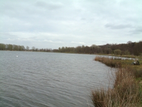
Filby Broad is one of five broads in the Trinity Broads. It lies within the Broads National Park, close to the village of Filby. The broad has a wide variety of birds and wildlife. It is connected to Ormesby Broad and Rollesby Broad via a narrow inlet under a road bridge. It is cut off from the main Broadland area and that means there is no water traffic for a majority of the time. As with the other Norfolk broads, Filby was a peat working and is now only about six to eight feet at its deepest. It is about half-a-mile long and surrounded on all sides by reed banks and trees, and one end of the Bridges Carrs area of the broad has been given Site of Special Scientific Interest status. Currently the main use is as a reservoir serving the Yarmouth and Broadland areas, owned and operated by the Essex and Suffolk Water Company. It has recently had a public boardwalk constructed at the north west side. The main occupant of the broad is the Norfolk Schools Sailing Association, which has occupied the site since the early 1970s and has built over time a sailing base, slip ways and dinghy park at the north end of the broad. The Association is a voluntary group that provides sailing training to children and adults within the county of Norfolk. This has created a body of water that has a very restricted level of human access leaving it an ideal spot within the broadland area for nesting birds away from the tourist bustle of the main rivers. More...
Hickling Broad is a National Nature Reserve established by English Nature and in the care of the Norfolk Wildlife Trust, who run boat trips around the reserve for visitors. It is also part of the Upper Thurne Broads and Marshes Site of Special Scientific Interest. In the 1990s, over £650,000 was spent on restoring the reserve, and invasive plants are kept under control by grazing hardy breeds of cattle, sheep and ponies from Eastern Europe. Water levels are managed, and the reed and sedge beds are regularly mown to encourage wildlife. It is the broad with the largest surface area, and the water is slightly brackish, due to its proximity to the sea. The navigation channel is only 1.5 m deep, with much of the broad being shallower; it has 5.9 km² of open water, making it one of the largest expanses of open water in East Anglia. It has the largest reed-bed in England and supports rare waterweeds such as the holly-leaved naiad and three rare species of stonewort. Amongst the rare insects is the Swallowtail Butterfly which feeds on milk-parsley, the Norfolk hawker Aeshna isosceles and emperor dragonfly. Birds that visit the resserve during the winter include cranes, goldeneyes, shovelers and teals, while bitterns, marsh harriers, pochards, water rails and Cetti’s warblers stay for most of the year. There is a waymarked walk around the broad. More...
Malthouse Broad is in the village of Ranworth. The name Malthouse is taken from the maltings that were once on the shores of the broad. The "Helen of Ranworth" was a traditional reed lighter, a boat that carried away the reed harvest, and used to ferry visitors from Malthouse Broad to Ranworth Broad. More...
Ormesby Broad - details to follow..
Oulton Broad is a large expanse of water and marsh which, although in Suffolk, forms part of The Broads. It is believed to be a remnant of medieval peat cutting. To the east it is linked by a lock to Lake Lothing which passes through Lowestoft and then into the North Sea. To the west it is linked by Oulton Dyke to the River Waveney. The Broad is the most southern area of water in the Broads system, and is a busy tourist and sporting centre. It is used for a variety of watersports, especially well known for powerboat racing. Facilities include a yacht station and moorings as well as a 'village' of holiday chalets. The Nicholas Everitt Park has an extensive water frontage. It is one of the few broads with residential areas adjacent, with houses to the north and flats to the east. The north side of the Broad is one of the most expensive residential area in Lowestoft, with large detached houses having lake frontage. While the eastern and north shores of the Broad are built up, the west and south-west are quiet and natural. This part of the lake can be reached on foot by walking through Nicholas Everitt Park and then by public footpaths and field across White Cast Marshes, an important nature conservation area. More...
Ranworth Broad lies in The Broads. It is one of the nature reserves in the care of the Norfolk Wildlife Trust. It has a floating visitor centre, a boardwalk and a bird observation hide. More...
Rockland Broad lies just north of the village of Rockland St. Mary. It has an area of approximately 50 acres and is completely surrounded by marshland and tall reed beds. It is linked to the River Yare by two dykes: the Short Dyke and the Fleet Dyke. From the village of Rockland St. Mary it can be reached via the Staithe opposite 'The New Inn'. The main navigable channel links the Staithe to the Short Dyke. A footpath also leads from the Staithe to an RSPB Bird hide which overlooks both the Broad and the adjacent Rockland Marshes. Some parts of the broad are badly silted. In the western part of the broad, known as The Slaughters, lie two Norfolk wherry wrecks. There is also a channel on the western side which links to Wheatfen Broad. Cantley Sugarbeet Factory is visible from the broad. The broad has good pike fishing and in 1912, it is said, that a fish weighing thirty one and a half pounds was caught. There are also bream, roach, tench and perch. A colourful Broadland character called Archie Taylor used to live in a cottage on the Staithe and made his living renting boats and cutting reeds. More...
Rollesby Broad - details to follow..
Salhouse Broadis situated by the side of the River Bure. The broad is situated just off the river and attracts little through traffic. It lies south of Hoveton Great Broad and about half a mile north of the village of Salhouse. The Broad is accessible from the landward side and moorings are also permitted to fee-paying boat visitors. The Broad is privately owned and managed in conjunction with the community of Salhouse. Salhouse Broad covers an area of 32 acres and is home to many forms of wildlife including the Norfolk hawker dragonfly and the swallowtail butterfly. Black Swans can sometimes be seen on this broad. More...
South Walsham Inner Broad - details to follow..
South Walsham Outer Broad - details to follow..
Wroxham Broad is on the River Bure near the village of Wroxham within The Broads National Park. The broad has an area of 85 acres and a average depth of 5 feet. It lies to the west of the Bure, with two openings between river and broad. It is home to the Norfolk Broads Yacht Club. Visiting boats are not allowed to land, but navigation is allowed. There is a locomotive at the Bure Valley Railway in Norfolk which is named after Wroxham Broad. Between 2000 and 2005 the island between the two entrance channels linking Wroxham Broad to the Bure was restored to stop erosion and improve the island's ecology, a joint project involving the Broads Authority, Norfolk Broads Yacht Club and the local landowner. Scrub was cleared and a stretch of piling installed, allowing sedge, reed and rush to grow back. By 2005 more birds, including kingfishers, were nesting on the island and the rare Cetti's warbler was spotted. Greater numbers of ducks, including pochard and tufted ducks, are now wintering close by and there is a much wider variety of wild flowers and marsh flora including orchids. In 2004, volunteers came across an unexploded Second World War hand grenade in the dredgings, which had to be exploded by an army bomb disposal team. More...
Page last updated: 4 May 2022© Nigel Peacock 2022